The Bay and Its Seasons
Reading the Tides at Rock Harbor
Rock Harbor is a tidal harbor that opens for about five hours a day. Learn to read the tide, plan a sailing window and understand the flats.
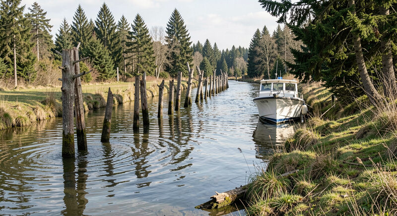
Rock Harbor is a harbor that empties. On the falling tide the water drains off the flats in front of it until the channel narrows to a thin ribbon between the sand, and on the rising tide it fills again until boats can float and move. For a few hours on either side of high water the harbor is open for business. Outside that window, it is a basin in the sand.
That rhythm is not a quirk to be worked around. It is the defining fact of fishing from Rock Harbor, and understanding it is the difference between a relaxed day and a wasted one. This guide explains how the tidal window works, how the channel is marked, and how to plan a trip around water that will not wait.
A man-made harbor on a shallow bay
Rock Harbor sits on the boundary between Orleans and Eastham, on the bay side of Cape Cod. It is not a natural deep-water port. It is a basin cut into the shore and kept navigable by dredging, because the bay around it is so shallow that without maintenance the entrance would silt in. The harbor serves a small commercial fleet and a line of sportfishing charter boats, and it is one of the few working harbors on this stretch of the bay shore.
Because the approach runs across wide flats, the water over the channel is limited. The practical rule that the harbor itself publishes is simple: the harbor is navigable from about two and a half hours before high tide to about two and a half hours after it. That gives roughly a five-hour window per tide, and it shapes everything that happens at the dock.
Why the window is so short
The bay is shallow, and the tide range here is large, often close to ten feet between high and low water. When that much water drains off a wide flat, the depth over the channel falls quickly. A boat that floats comfortably at mid tide may be sitting on sand two hours later.
This is not unique to Rock Harbor, but it is more pronounced here than in most New England harbors because of how far the flats extend. At dead low water the dry sand can reach nearly a mile out toward the open bay. Boats do not simply wait at anchor for the water to return; they plan to be out and back within the window, or they take a mooring and stay put.
Reading the channel markers
The channel into Rock Harbor is marked in a way that has no real equivalent elsewhere. Instead of only buoys, the approach is lined with cut spruce trees driven into the sand at low water, the famous trees in the water that guide boats through the shallowest stretches. The practice goes back centuries on this coast, and it works because the trees stand exactly where the water is deep enough and nowhere else.
For a visiting boater, the lesson is straightforward. The channel is narrow, it moves with the sand, and it is not forgiving of a guess. Local knowledge, a chart updated for the season, and the markers themselves matter more here than in deeper harbors. An angler going out on a charter can leave that to the captain, but anyone running their own boat should treat the entrance with respect.
Planning a trip around the tide
Because the window is fixed by the tide rather than by the clock, a trip from Rock Harbor is planned backwards from high water. A half-day trip fits neatly inside one window. A full-day trip has to reckon with the fact that the harbor closes in the middle of it, which is why full days are often built around a longer run to deeper water or a careful return on the next tide.
The practical questions an angler can ask before booking are simple. What time is high water on the day I want to go? Does the trip leave and return inside the window? If the plan changes with weather, how does the schedule move? A captain who fishes this harbor every day will have the answers ready, and the answers will be built on the tide, not on convenience.
The flats beyond the harbor
The same flats that make the harbor tricky are also part of why the fishing is good. The shallow water in front of Rock Harbor warms quickly in the sun, it holds bait, and it draws striped bass onto it to feed in the early and late hours of the day. Anglers who understand the tide can use the flats deliberately, fishing the last of the flood as the water pushes bait onto the shallows and the first of the ebb as it drains off.
That is the double edge of a tidal harbor. The water that limits when you can leave is the same water that makes the fishing worth leaving for. Learning to read it, rather than fight it, is the whole game. The guide to Billingsgate Shoals looks at the largest piece of structure the tide works over, and the section on the bay and its seasons sets the tides in the wider year.
A harbor with a schedule
Visitors sometimes arrive at Rock Harbor at the wrong hour and find a quiet, half-empty basin, the boats resting on the mud and the channel a thread of water. A few hours later the same harbor is busy, with boats slipping out one after another to make the most of the tide. Both pictures are accurate. They are the same harbor at different points in the same cycle.
Once an angler accepts that the harbor runs on the tide and not on the clock, the rest of a Cape Cod Bay trip becomes easier to plan. The month by month guide to the season explains what to expect from the water through the year, and the guide to a first charter trip covers how a day on the bay actually runs once the boat is under way.